
By Harry F. M. Marson, Third-Year History
Strolling through the pleasant scenery atop St. Michael’s Hill, few would suspect that the area harbours such a grim past. The junction where Cotham Road meets Hampton Road once housed Bristol’s execution ground for convicted criminals, known locally as Gallows Field. The site now occupies a set of rather unassuming landmarks, betraying few physical clues of its previous purpose: a mini roundabout, Cotham Parish Church, and the Students’ Health Service.
Gallows Field stood immediately adjacent to Bewell’s Cross – a stone boundary used to mark the northern edge of Bristol County. The two locations are almost inseparable in this sense. This obscure boundary marker would prove critical to helping historians identify the present-day location of the old execution ground. In 2024, the University of Bristol’s own Dr. Evan Jones located Gallows Field by analysing survey maps from 1792, alongside archival plans from 1829. Using said documents, Jones was able to pinpoint the location of Bewell’s Cross. Given the proximity between the Cross and Gallows Field displayed on the documents, identifying the physical execution ground itself was a straightforward task. [1]
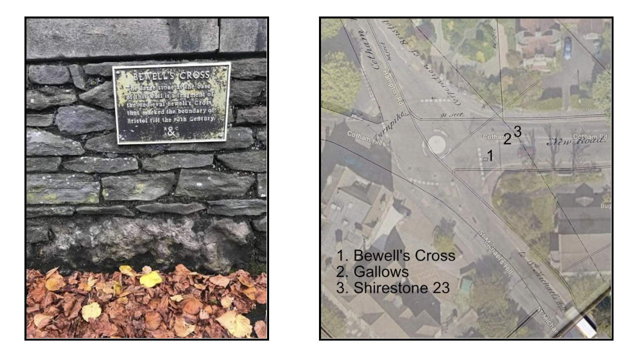
Plaque at Bewell’s cross and a map demonstrating Bewell’s Cross, the Gallows and Shirestone 23. Image credits: Bristol 24/7, article by Martin Booth, ‘Exact Location of Bristol’s Gallows Rediscovered by Historian’.
Once Gallows Field’s present-day location was identified, the natural follow-up question emerged: when exactly did it begin, and cease, operation? Again, to answer this we look to Bewell’s Cross. The first written record of the Cross’ existence dates back to an inspection of the city’s boundary markers in September 1373. [2] But this does not tell us whether or not executions had begun at the site by that time. William Worcester’s topographical survey of Bristol in 1480 provides a more definite answer, describing the ‘tall stone appointed as the boundary of the franchise of the town of Bristol, near the cross and the site of the gallows for the legal punishment.’ [3] The site continued to function as an execution ground for the next four and a half-centuries, remaining in constant use as late as the 1700s. In his Annals of Bristol (1893), John Latimer recalls the cases of 138 individuals who were hanged there during the 18th century, although Latimer himself does not regard his list as the full record of executions. [4] This admission from Latimer speaks to how extensively Gallows Field was used; given the high frequency of executions, even dedicated historians of Bristol are unable to definitively ascertain how many perished there over the centuries. In 1820, the city’s gallows were abruptly relocated to the roof of the New Gaol on Cumberland Road, and executions atop St. Michael’s ceased. [5] Infrastructure developments would see the former gallows quickly repurposed. The construction of Cotham Road in 1829 cut directly through Gallows Field, creating the landscape that we see today. [6]
Throughout its nearly half a millennium in operation, Gallows Field served as the final destination for countless condemned men and women. It was here, between 1556 and 1557, that a coterie of 280 Protestant artisans, clergymen, and labourers – known collectively as the ‘Marian Martyrs’ – were burned alive by Queen Mary I for heresy against the Catholic Church. This particular case gained nationwide and even international attention, being featured in John Foxe’s Book of Martyrs (1563) – a seminal work in the field of Protestant history and martyrology. [7] Lesser-known local criminals also met their fate here, including the likes of highwayman Jenkins Protheroe. Standing under four feet tall, Protheroe ambushed his victims by posing as an injured child before robbing them of their valuables. Ultimately, Protheroe would face the judgement of Gallows Field in 1783, with his corpse being gibbeted in chains on Pembroke Road for good measure. [8]
Further framing the site’s history through a lens of bleakness, the local authorities ensured that the final journey of the condemned became a public spectacle. Clasped in irons, the condemned were forcibly marched from Newgate Gaol (the local prison), up Christmas Steps and towards St. Michael’s Hill. The condemned were permitted, however, to stop for one final drink at the White Bear – the last inn along the execution route – before facing the noose. [9] This cruel practice exhibits a poignant symbolism, with the route itself resembling that of Christ’s Via Dolorosa – no doubt symptomatic of contemporary English society’s widespread Christian values. The practice also most likely served a practical purpose, insofar that the procession of the condemned was designed to be witnessed by the civilian population, probably with the goal of deterring other potential criminals.
Today, few physical traces remain to denote the erstwhile existence of Gallows Field. The primary remaining landmark is a solitary fragment of Bewell’s Cross, commemorated with a rather faded turquoise plaque. [10] The White Bear pub remains standing too; still a popular location for locals and students alike, albeit now without frequent visits from soon-to-be-executed prisoners. In the absence of grand landmarks commemorating public spaces (as is the case with Gallows Field), it is easy to forget that the physical locations we now walk once held vastly different purposes. Although the story of Gallows Field is not a particularly cheerful one, it is nonetheless important that we recognise the now repurposed space as an important heritage site in the study of Bristol’s civic past.
References:
[1]. Evan Jones, ‘Locating Bewell’s Cross’, Bristol Record Society (2024) <https://bristolrecordsociety.org/stories-from-the-archives/locating-bewells-cross/> [accessed 7 October 2026].
[2]. Norah Dermott Harding, Bristol Charters, 1155 – 1373 (Bristol Record Society Publications, 1930), p. 157.
[3]. Frances Neale, William Worcestre: The Topography of Medieval Bristol (Bristol Record Society Publications, 2000), pp. 86 – 867.
[4]. John Latimer, The Annals of Bristol in the Eighteenth Century (Butler & Tanner, 1893), pp. 136 – 138, 294.
[5]. Evan Jones, ‘Locating Bewell’s Cross’.
[6]. Ibid.
[7]. John Foxe, Foxe’s Book of Martyrs (Edwin Hunt, 1845), pp. 203 – 205.
[8]. ‘Take a Dark Tour of Bristol’, Visit Bristol & Beyond (2025) <https://visitbristol.co.uk/blog/post/dark-tour-of-bristol/> [accessed 7 October 2026].
[9]. ‘Discovery Sheds a New Light on Lost Medieval Bristol Landmark’, Medievalist.net (2024) <https://www.medievalists.net/2024/03/discovery-sheds-new-light-on-lost-medieval-bristol-landmark/> [accessed 7 October 2026].
[10]. William Ayres, The Highbury Story: Highbury Chapel, Bristol (The Independent Press, 1963), p. 5.
Edited by Yasmin Shaoul